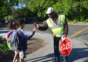
Putting Crossing Guards on the Map
See crossing guard locations on the map.
Leader
Daniel Stone
Location
First Street Newark, NJ 07103
About the project
See where the crossing guards in your community are.
We aim to make location and schedule data for crossing guards freely available on the internet. We want the technology to place the crossing guard data on a map because that is how people make travel plans.
We are open data advocates. By placing crossing guard location information in the public domain, app developers can incorporate the data into future technology and innovate community transportation.
The Steps
There are three components to the project:
1) Get communities to provide real time crossing guard location. We will work with public officials to make sure they have the information systems in place to provide the data securely.
2) Put all data collected on a central map. We will build a web site so that community groups can easily access the data on a visually appealing map.
3) Develop a data standard so that crossing guard location data can mature into "Big Data." We will work in the data community for a reliable and uniform data standard that allows easy sharing of the data.
Why we‘re doing it
- For healthy children - Walking to school is a great way to get out of doors and exercise. Less than 1 in 5 students currently walk to school.
- For safe crossing guards - In New Jersey, crossing guards are the most dangerous municipal job. When motorists are aware of their location, their risk is reduced.
- For earth's atmosphere - When students walk, they reduce the pollution from the trip in the car they would have taken.