project leader
Tim B
location
2 Whitney Rd. Suite 11
(Merrimack County)
latest update rss
In the Final week

the project


“Example of a low stress street” by Ann <https://www.flickr.com/photos/81325557@N00/> & licensed under by-nc-nd/2.0 <https://creativecommons.org/licenses/by-nc-nd/2.0/

What if you could help make it safer for you and your friends to go more places by bicycle?  You can, by supporting LeTS Roll!  By using the Minetta Transportation Institute method of mapping the Level of Traffic Stress (LeTS) that bicyclists experience on our roads, we can help planners and advocates identify a few key investments that will make a big difference in how safe you feel while bicycling.  When you feel safer, you’ll ride more, and getting more people riding actually does increase the safety for all bicyclists by making drivers more aware.

Think of the last trip you made to work, home, school, or your favorite relaxation spot.  Now imagine taking that trip on a bicycle.  Parts of it probably seem safe enough on a bicycle.  Those are the low stress bits.  But there are probably other parts where you’d say “No way!  It’s too dangerous to ride a bike there.”  Those are the high stress bits.  If any part of your trip is on a high stress road, you probably won’t go by bicycle.  Those high stress areas effectively surround the low stress areas, turning them into islands.

Our project will map the stress levels of our streets and roads to highlight the comfortable areas and the scary sections.  That lets us see where improvements can be made that will make you feel safe enough to make your trip on a bicycle.  The Minetta Transportation Institute has conducted research that shows stress mapping is the most cost-effective method for making our roads safer and getting more people out riding their bikes.

A picture may be worth a thousand words, but a good map that brings people together and helps reveal solutions is worth a million.  Please donate now to help get more people riding more often.

the steps

·     Raise enough money by March 10, 2015, to hire a summer intern to collect data on streets:  e.g. lane widths, speed limit, parked cars, etc.

·     Use data to assign stress levels to each street in the project area.

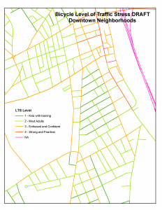
·     Create maps that use color to show stress levels.  This makes low stress networks and high stress obstacles easy to identify.

·     Show municipal leaders and bike advocates how to use the maps.

·     Maps allow communities to identify road projects that have the biggest return on investment in creating connected low-stress networks.

why we're doing it

The biggest reason more people aren’t out riding bikes is fear.  If we can help make bicycling less scary by helping communities identify where to make the best investments, more people will ride.  And as studies have shown, there really is safety in numbers.

budget

DISBURSEMENT BUDGET (as of 6/22/15):


RAISED = $2,085.00
ioby Platform Fee  $35.00
3rd Party Payment Processing Fee (3%) $59.71
TOTAL TO DISBURSE = $1,990.29

We will be spending 100% of the ioby raised funds on intern salary for the Level of Traffic Stress Project.

Revised budget:
Intern
$2000 from Restricted funds dedicated to continuing Level of Traffic Stress work.
$1,990.29 from IOBY Campaign.
$931.94 donation to BWANH for LTS work.
Total for intern: $4922.23

$500 – Harvard Pilgrim Mini-grant for LTS (materials and expenses)
Total for travel, printing, materials (all non labor expenses) $1000
Complete Campaign total: 5922.23


ORIGINAL BUDGET:

$4950 for an intern. (11 weeks, 37.5 hours/week, $12/hour)

$250 for materials consisting of large plots to produce maps and regular handouts explaining the process.

$500 for local travel for data collection.


SUBTOTAL = $5,700
ioby Platform Fee  $35
3rd Party Payment Processing Fee (3%) $171
TOTAL TO RAISE = $5,906


updates

In the Final week

Momentum is building and donations are coming in from out of state as well as in state.  An eight year old supporter donated his age!  Thank you.  Tell your classmates!  As we come into the weekend and you see weekend friends on ski slopes, at your place of worship, at the transfer station, etc. please mention the campaign.  The Alliance for Biking and Walking post generated donations.  Thank you for promoting LeTS Roll!. Together we can do this.

We're starting to Roll! Thank you early donors!

We are so grateful to those who have donated so far.  Even though this phase of the project is to map the stress levels experienced by bicyclists in Central New Hampshire, it's part of a much bigger effort.  Already, five pilot cities in our state have begun stress mapping projects.  Manchester is already using this data to help them see where small improvements in bicycle infrastructure would connect isolated low-stress networks to greatly multiply the number of destinations that can be accessed by bicycle.

If you want to read more about stress mapping, here are links to articles explaining the method:

http://www.bikeleague.org/content/summit-big-idea-low-stress-bicycling-networks

http://transweb.sjsu.edu/project/1005.html

Thanks again for donating.  Tell your friends that they can be part of history!  They can help make New Hampshire streets safer and more inviting for bicyclists, and soon we'll see people reaching for handle bars instead of car keys when they head to the grocery store.

photos

This is where photos will go once we build flickr integration

donors

  • Alex Bernhard
  • Anonymous
  • Richard Kole
  • Robert S.
  • Paul Susca
  • Andrew B
  • David Sky
  • Sheryl R-K
  • Chuck Redfern
  • Darren F
  • Michele Chalice
  • Scott Bourcier
  • George B.
  • Anonymous
  • Anonymous
  • Murray C.
  • Don
  • Fred McGarry
  • Anonymous
  • Leslie T.
  • Bernard F.
  • Rob & Juliana
  • Greg Bakos
  • Anonymous
  • Brian B.
  • Anonymous
  • Plan NH/Vibrant Villages NH
  • Anonymous
  • Ken Colburn
  • linda g.
  • Anonymous
  • Dave T.
  • Tim B.
  • Rebecca H.