Gowanus Low Altitude Mapping (GLAM)
Gowanus Low Altitude Mapping (GLAM) is a volunteer-driven initiative to create detailed aerial photos of the Superfund-designated Gowanus Canal, using cameras and balloons.
Leader
Natasia Sidarta
Location
94 9th Street Brooklyn, NY 11215
About the project
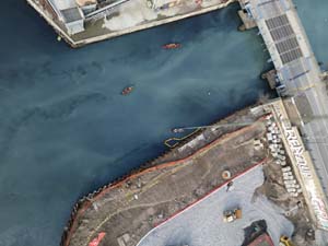
In an ongoing effort to document the ever-changing Gowanus Canal and its environs, Gowanus Canal Conservancy has partnered with Public Laboratory, to create the Gowanus Low Altitude Mapping (GLAM). GLAM is a creative, volunteer-driven initiative to create a systematic archive of accurate and incredibly detailed photographs of the environment in and around the Gowanus Canal using readily available and inexpensive technology. Using a point and shoot camera and publicly available firmware, these cameras are modified to take photographs at fixed intervals; they are paired with balloons or kites to obtain a large number of stunning birds-eye-view images captured from a low altitude (several hundred feet). The images are culled, stitched together, and stretched using Geographic Information System (GIS) software to create remarkably accurate geospatially referenced aerial maps.
The Steps
- February 2014 : Meet with GLAM Volunteer Coordinators to plan balloon mapping strategy; purchase all required materials
- February 2014 - ongoing : Recruit volunteers (promote on GCC website and social media, cross-promote on partner organizations, i.e. Public Lab)
- March 2014 : Balloon Mapping Outing #1
- April 2014 - ongoing : Stitch photos from Balloon Mapping Outing #1, upload results on Public Lab website, GCC website and social media
- July 2014 : Balloon Mapping Outing #2
- July 2014 - ongoing: Stitch photos from Balloon Mapping Outing #2, upload results on Public Lab website, GCC website and social media
- December 2014 : Balloon Mapping Outing #3
- December 2014 - ongoing: Stitch photos from Balloon Mapping Outing #3, upload results on Public Lab website, GCC website and social media
- March 2015 : Balloon Mapping Outing #4
- March 2015 - ongoing: Stitch photos from Balloon Mapping Outing #4, upload results on Public Lab website, GCC website and social media
Why we‘re doing it
The Conservancy will use the maps to identify troubled areas along the Gowanus Canal, track the progress of areas that have been improved with plantings or street-gardens, and create a valuable visualization of both the positive and negative influence we all can have on this federally-designated Superfund waterway. We hope to create a public record and systematic archive of accurate and detailed photograph of the environments in and around the canal - a project that will have critical significance as the Superfund cleanup is underway.